 Department of Geography and Planning
The laboratory is housed in the Department of Geography and Planning and supports field and laboratory research in hydrology, climatology, and geomorphology. The wet lab section houses a Los Gatos water isotope analyser. Fume hoods, bench space, centrifuge, scales, ovens and freeze dryer support water, sediment and soil research. Refrigerator and freezer space is dedicated for samples. A walk-in fridge is available for sediment core storage.
Sediment core processing facilities include a thin section embedding and preparation facility. Additional dating and sediment related analyses are available on campus. Several dissecting and emersion microscopes are available for sedimentology and general microscopy.
Space and equipment to support data logger and sensor testing and deployment and prototyping is available.
Several computers provide general, GIS and instrument related support. A number of laptop computers are available for fieldwork.
Lake and marine instruments include numerous CTDs (RBR, YSI), submersible loggers, sediment accumulation sensors, and trap systems.
A number of gravity, percussion, and vibracoring systems are available for use. A Zodiac boat and motor is also available.
Two rotary-wing UAVs and camera systems are available for low-level precision photography. A DJI Phantom is used for general purposes and a custom hex-copter with a larger camera payload was built in 2016. A Leica Total Station and related equipment is available for ground control.
Cape Bounty Arctic Watershed Observatory (CBAWO)
Scientific infrastructure
The Cape Bounty Arctic Watershed Observatory (CBAWO) was established in June 2003 as a paired watershed experimental design. Similar catchments additionally drain into paired lakes, both of which contain clastic varved sediments. CBAWO has since grown to encompass a network of weather, stream, soil and lake monitoring sites have been maintained to provide baseline information for process and experimental studies. Over 75 data logger-sensor systems are in operation, many year-round, collecting diverse scientific data to support research.
Two weather stations operate with annual, on-site download of data. A main station, located between the two watersheds, collects comprehensive temperature, humidity, precipitation, radiation and wind parameters at hourly intervals. A second station in the headwaters of one river records air temperature and precipitation.
A number of river and stream stations operate seasonally. Stations located on the main rivers and include discharge, water temperature, turbidity, and electrical conductivity measurements at 10 minute intervals. Extensive manual samples for water chemistry and sediment load have been collected as well, and regular pump sampling was initiated in 2007. Regular water contaminant and ecological samples have also been collected at these stations. Stations are manually rated for discharge at regular intervals through the melt season.
Additional stream stations are located on tributaries and experimental watersheds. These stations measure discharge, water temperature, turbidity, and electrical conductivity.
Soil pore water pressure is recorded at several locations in support of geotechnical research. Sensors are located near the base of typical active layer.
Numerous soil and permafrost temperature stations are located in smaller watersheds in different vegetation types and permafrost settings. These stations record soil temperature to 70-90 cm depth (typical active layer depth) and three stations record permafrost temperatures to 7 m depth.
An eddy covariance carbon dioxide flux tower was established in June, 2008 in collaboration with E. Humphreys (Carleton University) and operates seasonally. Portable chamber measurements of CO2 and gas samples have also been collected in a number of additional fixed locations since 2006.
An International Tundra Experiment (ITEX) experiment was established in 2008 during the International Polar Year. The experiment utilizes open topped chambers to increase temperature and snow fences to augment snow cover. Vegetation plots have been established in a replicated full factorial experimental design with soil trace gas collar stations and soil moisture and temperature stations.
A growing collection of remote sensing imagery (IKONOS, Geoeye, Worldview-2 and -3, and Radarsat SAR) and related ground truthing has been acquired for geomorphic, permafrost, biomass and vegetation mapping purposes.
Limnology stations on both lakes are seasonally instrumented with temperature loggers and moored CTDs. Manual sediment traps are located in the water columns and recovered at frequent intervals during the field campaigns. Water samples are collected from the water column at regular intervals along with CTD casts on station. A large number of sediment cores have been collected with emphasis on the locations where limnological measurements have been collected. A comprehensive sidescan sonar and acoustic survey of both lakes was completed in 2015 to enhance limnological and sedimentological research.
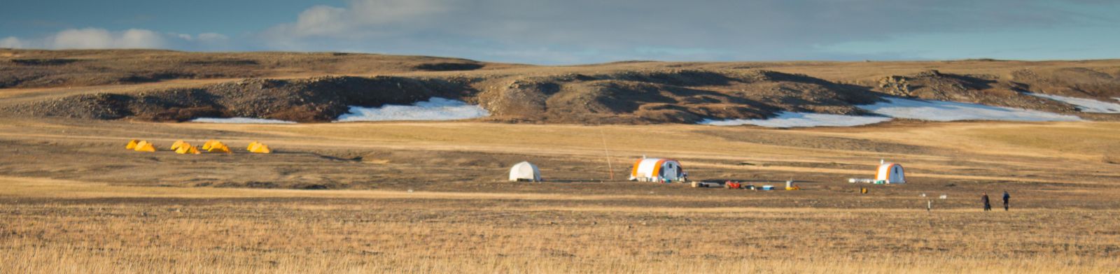
Camp Infrastructure
The camp is operated seasonally and capable of housing up to ten people and located in a central location near an airstrip, the camp is generally snow-free on gravel/cobble substrate. A heated Weather Haven tent is available for general camp activities, along with individual sleeping tents. A new (2015) laboratory tent provides clean space for water and sample processing for intensive sampling, along with freezers for sample storage. Solar power is available for general uses with a generator backup.
To minimize the impact on the landscape, most travel is on foot. During the late winter, snow machines are used to move heavy equipment. All-terrain vehicles are used sparingly to move between the lakes.
Small inflatable (Zodiac) boats are used on the lakes to gain access to the ice pan or on open water. Ice cover is usually safe to operate from until mid-July.
The observatory is serviced by charter Twin Otter and helicopter aircraft from Resolute, Nunavut with the Polar Continental Shelf Program (Natural Resources Canada). The lakes are suitable for ski landings until early June and a summer airstrip is located at camp on the north end of the West Lake. Flying time to Resolute is approximately 1.75 hours for a Twin Otter and approximately 3.5 hours with a helicopter.
We welcome community members and collaborations and have hosted many researchers that have operated on independent projects in the region.
